There are users requesting EURO4M data sets archived in Sweden (SMHI and NSC) and some of it through the CLIPC project, others though voluntary help from SMHI. There is a huge potential due to the long 25-35 time series present in some of the data sets.
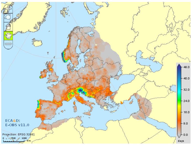
User oritented products continue to be constructed from the E-OBS data sets, both from observations but mainly from the interpolated, gridded data sets. Climate information bulletins are regularly published and below is shown the number of day with heavy precipitation.
The ADAGUC Web map server is available at KNMI since 2009 and can be used to display and overlay all sorts of data inlcuding observations, from NetCDF files.
ESGF (Earth System Grid Federation) is used for distributed data in the climate community and will be demonstrated from some of the UERRA data as well. This is linked with the work in the adjoining FP7 CLIPC project where a Climate Information Portal is the core of the project.

There is also a part of the project that deals with hydrological modelling where the input comes from the reanalyses. A first such work was done with the EURO4M data as input and more will follow when the UERRA reanalyses are available.
A User workshop (of reanalyses) was organised in Toulouse 3-4 February 2016 and it was well attended by both UERRA data producers and evaluators (in terms of QA) and users from the climate change research and energy industry and some commercial applications like insurance and media.
Some 20 users described and showed their current and projected needs of climate reanalysis data. Many want it at very high resolution both in space and time and over long multi-decadal time extent. Also a dense vertical resolution in the lowest part of the atmosphere is needed. The following is a condensed version of what came out from the Workshop and it quite typical of user needs but not exhaustive as certainly not all types of users could be represented here.
Variables:
2m temperature, solar, direct and global radiation, wind
wind at 50, 70, 100, 150 m and more, wind gusts
profile of water vapour and temperature
Spatial resolution
From 25 km to 10, 5, 2.5 km and even higher, below 1 km and a few 100 m (downscaling?)
Time resolution
Generally 1 hour
Time period
30 – 50 years or more
Applications:
Downscaling climatology
Forcing high resolution models
Validating models
Energy:
wind potential and climatology, balance in the grid
Solar energy and potential and climatology
Climate modelling
Climate services
Insurance and severe weather statistics, extreme values
Agriculture (and forestry):
Growing season index
Winter severity